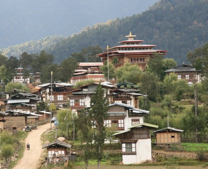
 Wangdue Phodrang (previously spelled Wangdi Phodrang) is a dzongkhag (district), of central Bhutan. This is also the name of the dzong (built in 1638) which dominates the district, and the name of the small market town outside the gates of the dzong. The name is said to have been given by the Shabdrung Ngawang Namgyal who was searching for the best location for a dzong to prevent incursions from the south. At the chosen spot the Shabdrung encountered a boy named Wangdi playing beside the river and hence named the dzong “Wangdi’s Palace”.
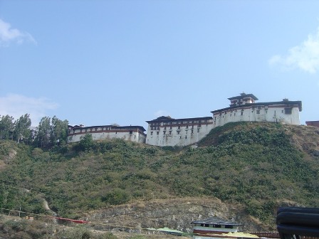 Wangdue Phodrang Dzong
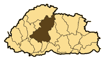
Wangdue Phodrang is bordered by Dagana and Tsirang dzongkhags to the south, Tongsa dzongkhag to the east, Thimphu and Punakha dzongkhag to the west, and Gasa dzongkhag and a small section of border with Tibet to the north.
Wangduephodrang Dzong was founded by Zhabdrung Ngawang Namgyal in 1638. It is located on top of a high ridge between the Puna Tsang Chu and the Dangchu, offering a spectacular view.
Wangduephodrang is about 4308 square kms with an elevation ranging from 800 to 5800 meters above sea level. The summers are moderately hot with cool winters. The areas in the north remain under snow during the winter and the district receives about 1000 mm of annual rainfall.
Wangdue is the second largest district in Bhutan, comprising of 15 vast and diverse geogs. They are Athang, Bjena , Daga, Dangchu, Gangtey, Gasetshog Gom, Gasetshog Wom, Kazhi, Nahi, Nyisho, Phangyul, Phobjikha, Rubeisa, Sephu & Thedtsho. Food security and rural access is the most obtainable in Thedtsho geog (were the present town and the developing Bajo town are located). They are the least accessible and found lacking in Athang (the most remote geog). Some of the Dzongkhag’s available infrastructures are as follows:
Hotel Dragon Nest 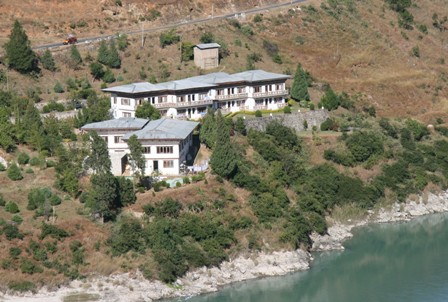
Wangduephodrang has about 65 % of its total land under forest cover, which consists of both broadleaf and conifers. Phobjikha geog is famous as the winter resting place of the black necked cranes where one RSPN office has been established. The Jigme Dorji Wangchuck National Park extends into the northern part of the Dzongkhag and covers almost 4 geogs. The acclaimed monastery, Gangtey Goenpa, is located in Gangtey geog and the well known site of pilgrimage Boed Langdra is located in Kazhi geog.
The higher geogs of Phobjikha, Gangtey, Sephu and Dangchu provide rich pasture for livestock, with approximately 3.5 % of the total area of the Dzongkhag under Tsamdro (pasture). There are about 39,380 heads of livestock with approximately 27,760 cattle heads in the Dzongkhag and 7,847 heads of poultry, thereby earning some income from the sale of livestock products through farmers’ groups involved in production, processing & marketing.
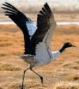 Black Necked Crane in Phobjikha Valley.
Chuzhing (irrigated wetland) dominates the agricultural activity, followed by Kamzhing (dryland), mixed farming and few patches of Tseri (slash & burn) cultivation. Paddy fields are mostly along the Dangchu and Puna Tsang Chu, with double cropping of rice as an important agricultural feature. Potato is an important cahs crop for the geogs of Phobji, Gangtey and Sephu and there is increasing citrus production in the geogs of Daga, Bjena, Phangyul and Rubeisa and ginger production in Daga and Athang geogs as a source of generating income. The lower valley towards the southern belt is best suited for sub-tropical horticulture crops such as oranges, mangoes, pineapples, guavas etc.
There are three paved roads in Wangdue Phodrang dzongkhag. The Lateral Road enters from the west at Dochu La Pass, crosses the Pana Tsang Chhu at Wangdue Phodrang dzong, and continues east to Tongsa. One spur road heads north from Wangdue Phodrang to the dzong at Punakha and slightly beyond. This becomes the footpath to Gasa. A second spur departs the Lateral Road halfway between Wangdue and Tongsa, traveling south a short distance to Phobji monastery and the Gangtey valley where the rare Black-necked Cranes (grus nigricollis) may be found.
 Gangtey Gompa / Phobjikha (3,000m/9,845ft)
In the mountains east of Wangduephodrang lies the beautiful Phobjikha valley, on the slopes of which is situated the great monastery of Gangtey, established in the 17th century. The village of Phobjikha lies a few km. down from the monastery, on the valley floor. This quiet, remote valley is the winter home of black necked cranes, which migrate from the arid plains of Tibet in the north, to pass the winter months in a milder climate.


No comments:
Post a Comment